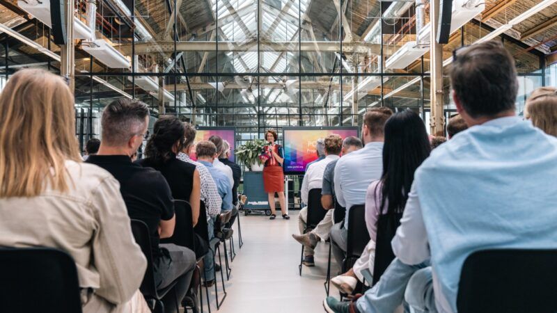
 Many of the world’s ports are focusing their digital developments on technology that supports smarter route planning with fewer emissions for their users. (Image by Port of Rotterdam)
Route planners: how ports help their users find the smartest routes
With the hopes of building a more sustainable industry, the world’s ports are developing technology that allows their users to create smarter, more sustainable routes. Learn how the ports of Rotterdam, Barcelona, Amsterdam, Antwerp, and Zeebrugge are removing bottlenecks in the planning process, thus making better use of time, building more sustainable routes, creating stronger transportation chains, and optimizing the movement of cargo across the world.
Posted on
05.07.2020
Many of the world’s ports are focusing their digital developments on technology that supports smarter route planning with fewer emissions for their users. (Image by Port of Rotterdam)
Imagine all of the steps a piece of cargo makes when shipped across the world. From the moment the container is loaded onto a truck, it commences a global journey of transfers, pick-ups, and varying steps in the supply chain. With trucks, rails, barges, and deep-sea ships, there’s a mass of options available that help complete this door-to-door voyage in a competent and timely manner.
However, with this deluge of transportation possibilities, comes the expected uptick in potential delays. The Port of Rotterdam, for example, finds that 30% of their port calls are late, meaning higher wait-times along the supply chain, associated costs, and negative effects on the environment.
Moreover, the extensive list of programs used to determine the best routes for each movement of cargo ends up costing more precious time in planning; time that could be used to win back the losses from common delays.
For this reason, many of the world’s ports are focusing their digital developments on technology that supports smarter route planning with fewer emissions for their users. By streamlining the planning process into a singular digital platform, shipping companies will improve supply chains with more intelligent routes and transfers that support the growing list of available options.
Digitalization is making it easier for shippers to get cargo to their clients in a timely manner, meaning smarter movement and a more sustainable shipping industry -one that uses technology to refine its best practices.
Explore the online tools that these ports are developing to improve their users’ experience by planning smarter, more sustainable cargo routes.
Removing bottlenecks in the planning process with the Port of Rotterdam
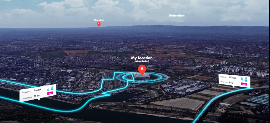
The Port of Rotterdam has long been aware of the bottlenecks of route planning, the most pertinent being the need to confront many sources before making route decisions. For that reason, they designed Navigate, their Smart Intermodal Route Planner.
Through this cloud-based platform, all shipping connections via Rotterdam are uploaded into the system, so that users can find, compare, plan, and navigate their ideal cargo routes.
“It’s a bit like Google maps but with more information. You fill in where you want to go with your cargo, and then you click through to find the right operators with these options.”
Thea de Vries, Director of Marketing & New Business, Port of Rotterdam
Navigate not only shows available connections and facilities but enables users to input their own preferences. It also includes a business directory with companies that are active in and around the Port of Rotterdam, giving them the opportunity to use container transportation in smarter ways for their supply chain.
This intermodal platform comprises 80 terminals in the Netherlands, Belgium, Germany, Poland, Hungary, Austria, and Italy and is built to present participating terminals on the basis of objective and comparable criteria. This help makes all transportation including rail and inland shipping in the region simple to manage.
While the Port of Rotterdam has a strong model for their route planning technology, other ports have demonstrated their own strengths for smarter routes.
Building more sustainable cargo routes with the Port of Barcelona
In an effort to cut down on carbon emissions, the Port of Barcelona developed Port Links, their intermodal tool which allows users to formulate detailed transport paths on an interactive map.
With an emphasis on open innovation, the port offers this tool publicly and free of charge so that all users can create these maps that account for estimated transit times and carbon emissions for land, port, sea, and the entire chain that connects them.
Port Links maps are representative of a number of helpful indicators including distance, transit time, and, most importantly, carbon emissions. With a keen focus on sustainability practices, the tool uses the same carbon emission calculation model developed by the Port of Barcelona under the ECOCalculator project to enrich their maps with carbon emission-based route planning tools.
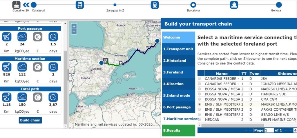
Providing a graphical representation of any given route, the Port Links models display aggregate results for distance, CO2 equivalent, emissions, cost, and transit times between any port of the world and European localisation through Barcelona.
All of this information enables shippers to factor rates of emission into each route that they plan, which further encourages the shipping community to take these numbers into consideration when organizing journeys.
Sustainability is a top priority for intermodal technology, but other factors such as wait-times and improving delays are pushing the development of these projects as well.
Making better use of time with the Port of Amsterdam
With sustainability at the forefront of port innovation, it’s crucial to look for ways to shorten the amount of vehicles and time used in the transportation of each piece of cargo.
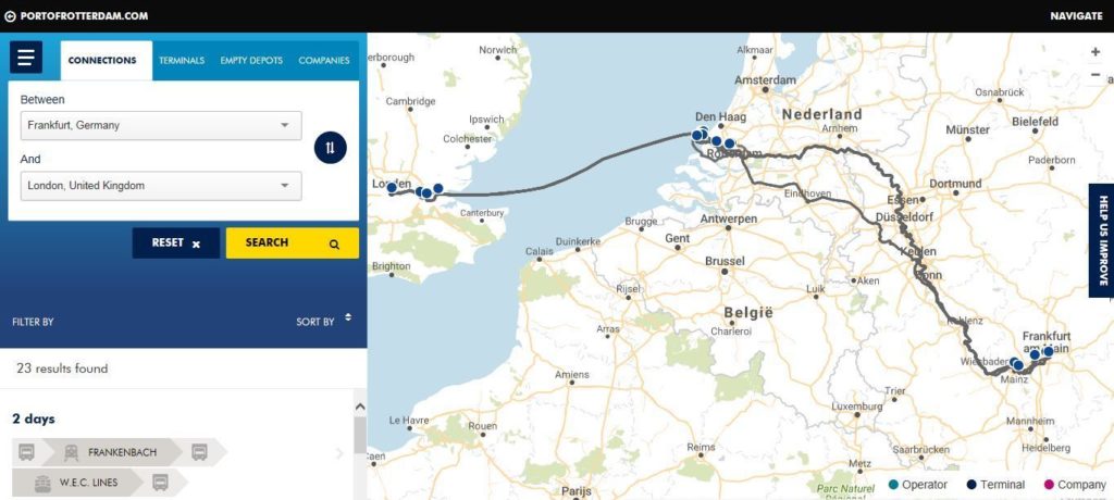
For this reason, the Port of Amsterdam developed their Intermodal Links Planner, which combines the time schedules of rail, barge, and short sea operators in Europe.
With downloadable and interactive schedules, users have the ability to take into account indicators such as departure and arrival terminal, departure delays, frequency, transport time, and operator name all in one document.
With technology of this nature, the public is able to select the best intermodal connections to ensure the most reliable and on-time scheduling options based on the best transport vehicles available at any given time. This means fewer modes of transport per shipment and less emissions in-consequence. All of this work enables ports to strengthen each link of the transportation chains, much like the goals of the Port of Antwerp.
Creating stronger transportation chains with the Port of Antwerp
The Port of Antwerp’s Intermodal Solutions collaboration within the Antwerp Port Community is set on providing solutions to build strong transportation chains that improve connection with the hinterland.
From this need, their Connectivity Platform was born. It reinforces the links of the transportation chains by providing their users with information about every transport option, while giving the best routes according to the needs of the individual.
The two main aims of the project are to access new target regions with innovative intermodal solutions and promote the modal split. In order to do this, the Antwerp Port Authority is building numerous strategic partnerships with hinterland hubs and terminals.
All of this work has enabled the Port of Antwerp to build stronger connections with 200 European Inland Terminals, which helps shippers create better routes. When it comes down to it, all of this technology is just another step towards complete optimization across the whole of Europe.
Optimizing the way cargo moves with the Port of Zeebrugge
Like all of the aforementioned examples, the Port of Zeebrugge also has procedures in place to improve route planning by optimizing every step in the process.
Together with Ecorys, the Port has jointly launched a new online tool, the Intermodale Route Planner, that gives port users access to complete intermodal offers for both direct and indirect connections.
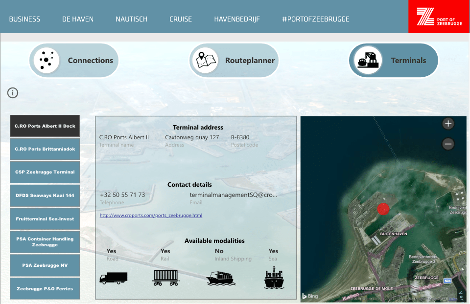
Their route planning optimization platform gives shippers an immediate overview of the timetables of rail, inland shipping, and short sea operators in Europe with a selection of the best intermodal connections between any two given locations. The planner determines the optimal route from around 16,000 direct terminal connections that are offered by 150 intermodal rail providers, including transport times and frequencies of connections.
And the Port of Zeebrugge is not alone in this; they are the fifth seaport in Europe to use the “Intermodal Links” developed by Ecorys, the independent online search engine that makes this technology not only possible but faster and more efficient.
As more ports develop and connect to similar technology, more information will be shared across platforms. This will only help shippers’ route planning process become better connected, more sustainable, and, of course, smarter.
The future of smart route planning
The key to route planning technology is bringing more ports together to develop a universal route planning tool for users. The higher the number of players that implement and use this technology, the higher the impact it will make on sustainability and route optimization.
One could even visualize the possibility of developing a sort of Skyscanner-style technology for route planning, as imagined by Thea de Vries of the Port of Rotterdam at the Smart Cities event in Barcelona.
This would enable shippers to view all possible routes across the world and compare based on criteria such as price, duration, and emissions. A task requiring global participation that would change the way shippers plan their routes.
But all of this demands that ports, shipping companies, and cities align on the need, development, and implementation of this technology and collaborate to bring it into fruition. As more ports connect together with it, the better the information -and routes- will become.