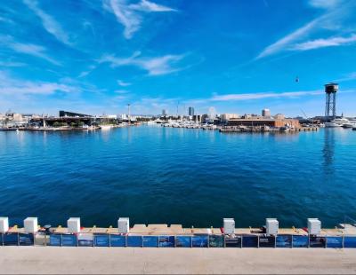
The understanding of the sea comes from the sky

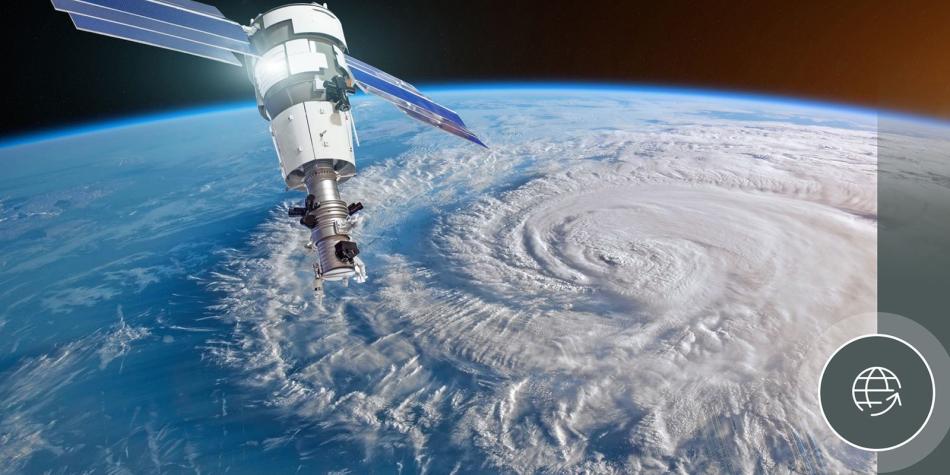
Sentinel, the evolution of satellites
The Sentinel satellite constellation of the Copernicus Program led by the European Commission and in collaboration with the European Space Agency, has revolutionized the way public agencies collect data. Before the launch of Sentinel-1 in 2014, satellites such as Envisat, weighing eight tons and equipped with sensors to measure the atmosphere, oceans, soil and ice, have been replaced by satellites specialized in observing concrete phenomena. The result is the increase in the quantity and quality of the information obtained.
Sentinel-2, for example, was designed to monitor the Earth's surface and the most recent, Sentinel-6 (also known as Jason-CS), to measure the consequences of changes in sea level.
“Each Sentinel satellite has specific sensors that collect data that has grown in volume and complexity. Once processed they facilitate an operational application that was previously only possible with private commercial satellites. Now, these are in the public domain and are contributing to further research and knowledge,” Laia Romero, isardSAT's director of operations and director of Lobelia Earth, explains to PierNext.
Satellites against climate change
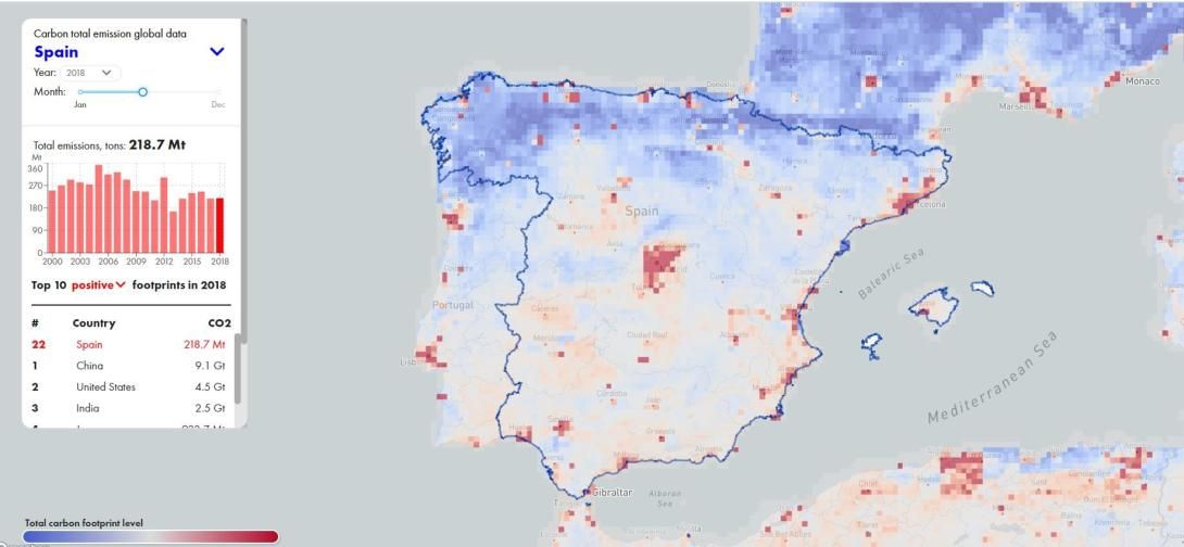
In addition to becoming specialized, satellites have expanded their range to obtain other variables such as the concentration of greenhouse gases. “Twelve years ago there were no satellites that measured the concentration of greenhouse gases in the air. This however changed in 2009 with the launch of the GOSAT satellite of the Japanese Aerospace Exploration Agency”, recalls Oleg Demidov, CEO of CarbonSpace, a satellite platform for carbon footprint tracking.
This start-up merges data obtained from international agencies with those collected by terrestrial sensors. The combination of various sources, mathematical models and Artificial Intelligence can estimate carbon footprint of different land areas, from fields and forests to cities, regions and countries.
Why are oceanographic satellites useful?
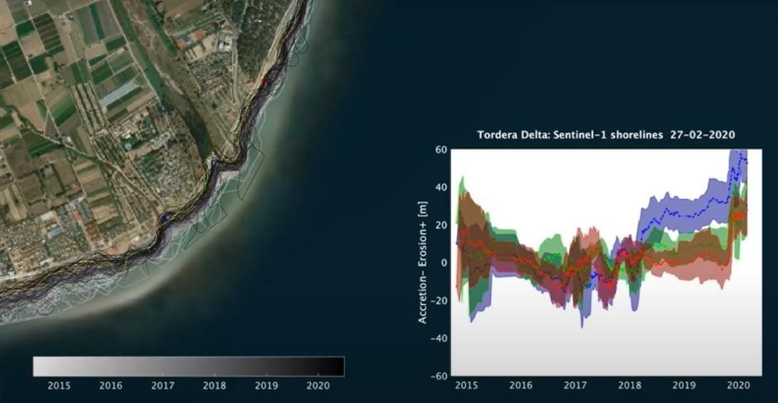
Using satellites to map the level of the sea surface is more justified by the difficulty of fixing sensors that can remain stable on the surface. The sky also offers its full coverage, especially radar technology that crosses clouds to, for example, identify plastics in the sea.
“With satellites we obtain a picture of reality, a neutral observation of what is happening and allows us, for example, at the climatic level, to study the rise in sea level. This observation generates very broad data sets on what is happening and from here make forecasts or study possible risks ”, says Romero.
The participation of the European Organization for the Exploitation of Meteorological Satellites (EUMETSAT) in Sentinel-6 / Jason-CS makes it possible for the Spanish Ports System to use data such as wave height and wind speed to obtain real time oceanic forecasts for a better sustainable management of the coastline, environment or marine safety.
Satellite data play a prominent role in port operations, security and infrastructure, as well as in the design of oceanographic monitoring and prediction models
Application of satellites in the maritime-port sector
The Spanish Ports System incorporates these data into its Wave Prediction and Sea Level Prediction models, "as a starting point or to correct or approximate a concrete mathematical model to reality," Romero explains. She is familiar with the project since isardSAT has participated in the development of the Sentinel-6 / Jason-CS.
Obtaining data on coastal erosion or waves can anticipate the decisions that a port will make at the infrastructure level. "Combined with artificial intelligence models, it allows us to detect when certain thresholds are exceeded or to know which areas require greater monitoring because they may be vulnerable to climatic risks," argues Romero.
"Port activity has very specific needs that require a high level of detail," he continues. It is also very susceptible to extreme events. In the event of erosion on the coast as a result of a storm, the infrastructure department must calculate how many m3 of sand it can move. And this answer is easier to obtain using data captured from the air.
At an operational level, the satellites also allow observing possible changes in the state of the seabed caused by the waves, identifying ships or restricting access to those of larger size. At a strategic level, the data obtained allows us to calculate costs and develop a planning strategy.
However, for satellites to play a more prominent role in daily operations, they must increase the frequency of passage to ensure that this management can be in real time and not ocasional, as is now the case.
Open data from satellites
In the case of CarbonSpace, which uses open data from satellites such as OCO-2, from NASA or Sentinel-5, Demidov explains that they are collaborating with several ports in the design of a commercial solution that allows them to face the challenges listed by its CEO: the need to source data from a significant number of sources (internal, satellite, terrestrial, from ships, etc.) and to train models to convert this information into carbon data.
"It would also be interesting if ports could obtain an older data set beyond the current two years because this time frame is not sufficiently solid history for decision-making," says Demidov.
The director of Lobelia Earth affirms that this increase in volume and complexity should be supported by internal training to accelerate the incorporation of these services and technologies in daily operations.
The opportunities of the "new space"
Finally, Romero explains that the trend started by the Sentinel satellite constellation will continue. “The so-called ‘new space’ sector is promoting new missions at different levels. Not only by large agencies but by different agents. This will happen more often in the future and the important thing is that this volume does not paralyze us but rather that we incorporate the different services as an opportunity.”